S
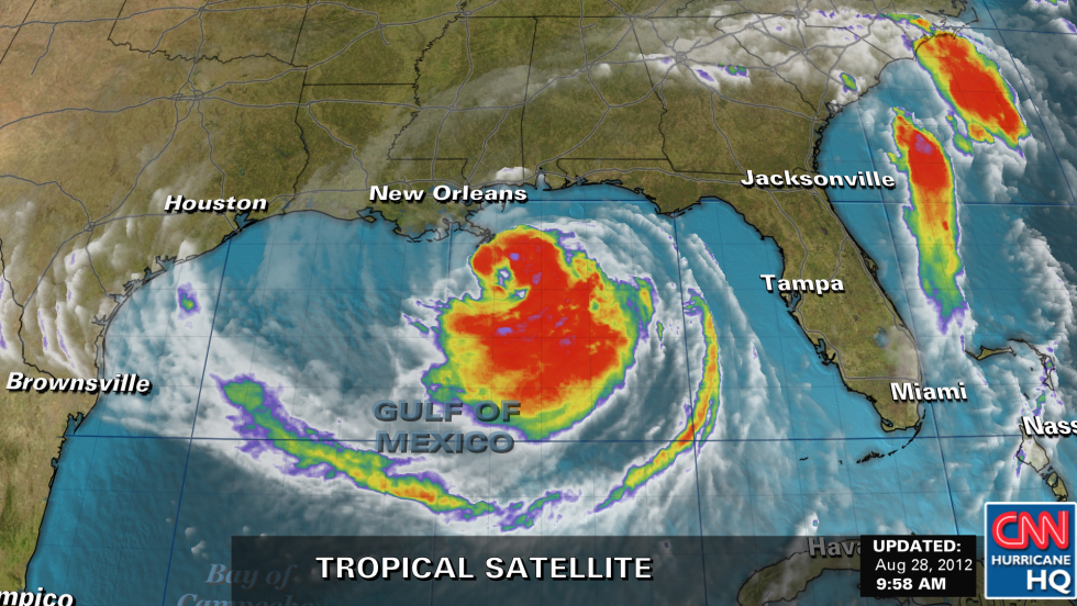
(CNN) -- As Hurricane Isaac barreled its way toward the Gulf Coast on Tuesday, authorities were out in force warning residents to take necessary, life-saving precautions.
"Do not let this storm lull you into complacency. That would be a terrible mistake," said New Orleans Mayor Mitch Landrieu.
Although Isaac -- just barely a Category 1 hurricane -- doesn't pack the punch of Hurricane Katrina seven years ago, such storms can "kill you or hurt you very badly," he said, citing flying debris and the dangers of driving through standing water.
"You've heard the stories of 'there but for the grace of God go I,'" said Landrieu, "unfortunately too many times."
He called on residents to be vigilant.
President Barack Obama, speaking from Washington, said, "Now's not the time to tempt fate. Now's not the time to dismiss official warnings. You need to take this seriously."
The president signed an emergency declaration for the state of Mississippi on Tuesday, as he had for Louisiana on Monday.
As of Tuesday afternoon, Isaac's maximum sustained winds were at 75 miles per hour, just strong enough to give it hurricane status, as it churned northwest through the Gulf at about 10 miles per hour, the National Hurricane Center said.
Forecasters expect Isaac to gain strength before it makes landfall, which could be as early as Tuesday evening.
"Hurricane conditions are expected to reach the coast by late afternoon," and the storm's center "should reach the coastline of southeastern Louisiana as early as this evening," the hurricane center said.

Isaac's forward movement is expected to slow down, and if it slows enough that it makes landfall after midnight, it will strike on Katrina's seventh anniversary.
In New Orleans, the Army Corps of Engineers told CNN it was closing the gate to the West Closure Complex, one of the world's largest pump stations, capable of pumping storm water at 20,000 cubic feet per second.
As of 1 p.m. CT, Isaac's center was about 135 miles southeast of New Orleans, and about 55 miles south-southeast of the mouth of the Mississippi River, the hurricane center said.
Hurricane-force winds extended 60 miles, and tropical storm-force winds extended 185 miles, the center said.
Isaac's slow pace will give it time to wreak havoc in some areas.
Total rainfall could be 14 inches in many places, and isolated parts of southeast Louisiana, southern Mississippi, southern Alabama and the Florida panhandle could get as much as 20 inches, the hurricane center said.
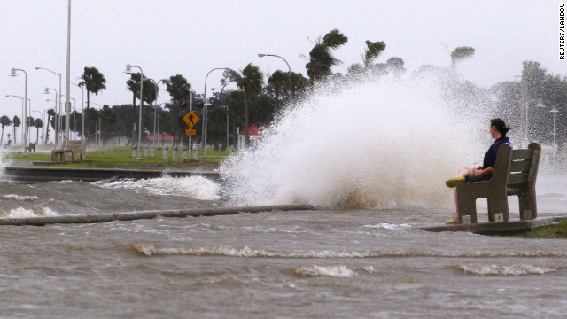
"The combination of a storm surge and the tide will cause normally dry areas near the coast to be flooded," the hurricane center said.
The storm could spawn tornadoes along the northern Gulf Coast on Tuesday, forecasters said.
The U.S. Coast Guard said it was was searching for a "missing jet skier" off the coast of Pensacola, Florida. The man's wife reported him missing Monday night.
As Hurricane Isaac builds, "the increasing winds and seas make search conditions extremely difficult and unsafe for aircrews," Coast Guard spokesman Timothy Williams said. "As Isaac approaches, Coast Guard aircrews will temporarily suspend their search efforts until the storm passes and weather conditions become safe enough to resume the search."
In Biloxi, Mississippi, popular casinos began to close down Tuesday.
The hurricane center called on people at ports, docks and marinas to "urgently complete" emergency preparations. For people who live on boats, it was time to "make final preparations for securing your craft before leaving it."
In New Orleans, Landrieu said officials "have a plan in place to secure the city, and we have a plan to respond quickly in the event of emergencies. We're confident that the work we've done in the last few years makes us fully capable of handling this type of storm."
By Tuesday morning, it was too late to evacuate New Orleans, Landrieu said.
Several New Orleans residents told CNN they planned to wait outthe storm and were not concerned that the nightmare of Hurricane Katrina in 2005 would be repeated. Isaac is not predicted to bring such dire conditions, and law and order have improved vastly, they said.
Jackie Grosch had to rebuild her home in Louisiana after Hurricane Katrina, but the St. Bernard Parish resident said she was going to wait Isaac out.
"Well, it gets old after a while -- packing up, taking the journey to wherever we're going to go. We thought about it and decided to stay," she said.
Nonetheless, her family is prepared with a generator, weather radio and life jackets -- "just in case."
A levee system fortified after Katrina will keep her home safe, she said.
"I don't know if it's going to be a true test, because they're saying it's not going to be that bad. But you never know what bad is. We didn't think Katrina was going to be bad, either."
Katrina made landfall as a Category 3 hurricane with 125-mph winds
Most of Katrina's nearly 1,800 deaths occurred when the protective levees around New Orleans failed, flooding the city. But Landrieu said the levees have had $10 billion in improvements since 2005, and the city's pump stations have backup generators ready in case of electrical outages.
"This is the best system that the greater New Orleans area has ever seen," said Col. Ed Fleming of the Army Corps of Engineers.
The U.S. Nuclear Regulatory Commission dispatched additional personnel to two nuclear plants in Louisiana: the Waterford plant about 20 miles west of New Orleans and the River Bend plant about 25 miles northwest of Baton Rouge.
As the storm heads north, its rain is expected to benefit some drought-ravaged states like Arkansas, Illinois, Indiana and Missouri.
Some people in low-lying Louisiana parishes and coastal counties and barrier islands of Mississippi, Alabama and northwest Florida were told to clear out ahead of the storm. I
The storm lashed Cuba and the Florida Keys over the weekend after slamming into Haiti, where at least 19 people had been reported dead by Monday, the country's civil protection agency reported.
The Hurricane Center projected storm surges of up to 12 feet in Mississippi and southeastern Louisiana.
But on Dauphin Island, south of Mobile, many residents were preparing to sit out Isaac at home as well.
"We are boarding up (and) getting supplies ready," said Alexa Alexander, who lives and tends bar on the island. "We've had a little bit of people leave Dauphin Island, but not much. Most of the locals are going to ride it out."
Dauphin Island was badly damaged by Katrina, which cut the island in half -- a gouge since filled by sand and rock.
In nearby Bayou La Batre, Alabama, shrimpers hunkered down.
"All the boats are coming in. We're anchoring them down and getting ready for this blow, hoping it's not too bad," Dominick Ficarino, the owner of Dominick's Seafood, told affiliate WPMI-TV.
Many airports across the region shut down.
Mississippi officials dispatched 1,500 National Guard troops to the state's three southern counties to help with emergency operations, as well as extra state troopers to ease traffic flow.
The state has distributed 10,000 sandbags to residents ahead of the storm.
"In short, we have done everything in our power to be prepared for the storm," Mississippi Gov. Phil Bryant said.
Most of the storm's ferocity bypassed Florida's west coast and the Republican National Convention in Tampa, where the schedule will begin in earnest Wednesday after organizers pushed events back a day because of concerns about the storm. The system passed well west of Tampa, although it did soak the bay area with heavy rain and blustery winds.
No comments:
Post a Comment